Real Results

Performance By The Numbers

LWD Quad Combo

Obtained Quality Data in First Deployment in 14 1/2-in. Shallow Water Wellbore, Saved 2 Days Rig Time and Reduced Operating Costs

Objectives

  • Log, drill, and ream in a 14-1/2 x 17-1/2 in. wellbore in an interval of 1,771 ft (540 m) with the kick-off point (KOP) at 3,904 ft (1,190 m) until reaching 53° inclination
  • Collect quad combo LWD measurements throughout this entire section
  • Adjust the velocity model to reduce the risk in the time-depth conversion, which can impact the estimation of probable geological columns
  • Perform evaluation and petrophysical characterization of the well to define the best areas for hydrocarbon production in the first reservoir zone
  • Obtain reliable density and porosity data during this section to characterize its porosity from the density and sonic data in a large diameter for these type of tools that are contact seeking to optimize times without having to run wire rope and reduce time and risks

Our Approach

  • Historically with this hole diameter, the customer had experienced problems acquiring information due to the lithology (sands, low consolidated-shales) and the standoff (distance between tool and the hole) resulting a complex scenario to obtain accurate density-porosity data.
  • Because of the known challenges associated with this section, Weatherford proposed an LWD quad combo to solve the three greatest needs: to be able to adjust the velocity model, geomechanical model, and characterize the entrance to the first of three zones of interest of this well.
  • The quad combo consisted of the following technologies: ShockWave sonic tool, HAGR sensor, MFR sensor, AZD sensor, and the TNP sensor.
  • The Weatherford team took into account that the density and neutron sensors are contact tools and were aware of the standoff present in this well (acknowledging there would be greater contact of the tool due to the inclination in those section) and, based on previous experiences, it was decided to use the azimuthal density at the base of the tool to ensure the measurements were as coherent to the formation.

Value to Customer

  • Weatherford’s expertise and technologies combined to acquire good quality data in this section and reduce overall time and costs by 2 days for the acquisition of the necessary information at this stage of drilling and expansion.
  • The data successfully characterized the deposit, enabling the customer to adjust the static and geomechanical models and avoid additional times during extra trips for wireline logging and, ultimately, reducing the risk of another wiper trip before running wireline.
Details

Location

Tabasco, Mexico

Well Type

Directional

Formation

Sand-shale and Miocene

Hole Size and Angle

14-1/2 x 17-1/2 in., 15 to 53°

Total Depth

1,804 ft (550 m)

Logging Interval

3,674 to 5,479 ft (1,120 to 1,670 m)

Products/Services

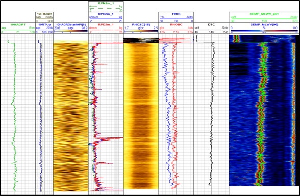
Composite log with the following information obtained: Gamma ray, total-azimuthal and image, resistivities, density image and density bulk, quadrant bottom, sonic porosity and semblance, and delta T c

Contact Weatherford

Take the next step in realizing the field of the future. Submit your details and one of our optimization experts will be in touch.