Real Results

Performance By The Numbers

ShockWave® Sonic Tool

Delivered Real-Time Compressional Slowness Data in Large OD Borehole Through Poorly Consolidated Formations in Mexico

Objectives

  • Log and drill in a 26-in. hole for 3,838 ft (1,170 m) in poorly consolidated formations without affecting ROP
  • Obtain logging-while-drilling (LWD) data (gamma ray, resistivities, and sonic)
  • Calibrate the velocity model and fit the seismic model to reduce uncertainty
  • Define the pressure model and avoid any contribution zone that could be present within the shallow and unconsolidated formations

Our Approach

  • Weatherford drew on its experienced teams from drilling services, logistics, operations, and engineering to evaluate this high-impact operation and, based on similar successful jobs in other regions, recommended that tools with an 8 1/4-in. outside diameter (OD) with a unipolar acquisition mode would be best for this customer.
  • The bottomhole assembly (BHA) featured an LWD package consisting of the HAGR high-temperature azimuthal gamma ray sensor, the ShockWave sonic tool, and the MFR multifrequency resistivity sensor, and a gamma ray sensor.
  • Based on the trajectory of the well, rate of penetration (ROP) proposals, and expected drilling parameters, Weatherford designed the BHA to provide the greatest possible stabilization of the ShockWave tool sensor, avoiding vibrations that could be harmful at the time of acoustic data acquisition during drilling.
  • In a single run, Weatherford drilled and logged 3,838 ft (1,170 m) within the Pleistocene and Miocene formations with an ROP average of 114.8 ft/h (35 m/h), acquiring deep resistivity, density, porosity, and sonic data for evaluating the reservoir.

Value to Customer

  • The LWD data identified the zone of the poor-to-moderately consolidated layers evidenced with the responses of the resistivities and delta T compressional (DTC).
  • The data empowered the customer to update the geomechanical model and achieve the optimal settlement of the casing and increased the depth with respect to nearby wells.
  • Weatherford validated the unipole performance for the first time in these challenging conditions, proving that its technology can provide good results to the customer in these stages, eliminating the use of cable logs or the possibility of not being able to log the well at all.
Details

Location

Huimanguillo, Tabasco, Mexico

Well Type

Vertical

Formation

Sand-shale, Pleistocene, and Miocene

Hole Size and Angle

26 in., 0°

Total Depth

3,838 ft (1,170 m)

Logging Interval

98.4 to 3,838 ft (30 to 1,170 m)

Product/Services

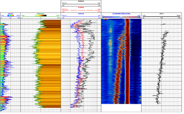
Composite log with the following information obtained: ROP, gamma ray, resistivities, semblance, and DTC log.

Contact Weatherford

Take the next step in realizing the field of the future. Submit your details and one of our optimization experts will be in touch.